VANK has urged the Ministry of Land, Infrastructure and Transport to review and improve its use of world maps, criticizing the continued reliance on the Mercator projection that significantly distorts the size of continents and portrays Africa much smaller than its actual scale.
Posting a proposal titled “Distorted World Maps and Africa: Let’s Correct Them, Ministry of Land, Infrastructure and Transport” on the national policy suggestion platform Woollim, VANK explained that it had also delivered the issue directly to ministry officials.
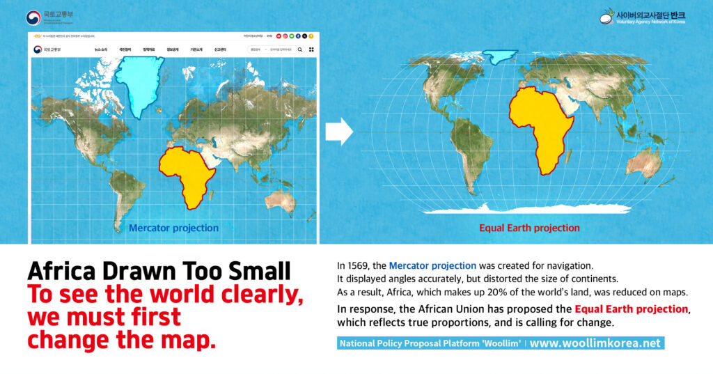
“The world map most familiar to us in daily life is the cylindrical Mercator projection, created in 1569 by the Dutch cartographer Gerardus Mercator,” VANK noted. “While it served navigational needs, it exaggerated northern hemisphere regions and compressed the southern hemisphere, shrinking continents such as Africa.” On Mercator maps, Greenland appears as large as, or even larger than, Africa, although in reality Africa is about 14 times larger.
VANK warned that this distortion goes beyond technical inaccuracy, reinforcing stereotypes and fueling biased worldviews. “Africa is a future partner of growing importance, with abundant resources and rapid demographic growth. Choosing distortion-free maps and applying them to public materials would be more than correcting a mistake — it would be a diplomatic message of trust and respect,” VANK stressed.
The problem, VANK argues, is not confined to classrooms or overseas errors. Earlier this year, in May 2025, the organization pressed the Ministry of Education to correct biased portrayals of Africa in elementary school textbooks, where the continent was described primarily as a passive recipient of aid. The ministry responded that it would actively review the matter and work to improve inaccurate perceptions.
Now VANK’s attention has turned to structural issues of cartography. Its survey of government-affiliated institutions revealed frequent use of the Mercator projection. The Korea Overseas Infrastructure & Urban Development Corporation (KIND) employed it in materials including its main website’s “Business Location” section, a 2025 English-language leaflet, and infrastructure cooperation booklets. The National Geographic Information Institute (NGII) applied it in children’s publications such as Children’s Map Journey and in its world blank map sets, as well as in its Korean-language brochures.
VANK also criticized the NGII’s World Map Projection Guidebook, produced in 2014, which explains Robinson, Mercator, Eckert IV, Goode Homolosine, and Winkel Tripel projections but omits the Equal Earth projection, developed in 2018. The Equal Earth projection, which more faithfully represents the true proportions of continents, has been officially supported by the African Union and promoted internationally through campaigns such as Africa No Filter and Speak Up Africa.
“You cannot create a perfectly accurate flat map of a round planet, but public institutions have a responsibility to use projections that minimize distortion and reflect areas and locations as fairly as possible,” VANK stated.
Lee Sei-yeon, a youth researcher leading the campaign, stressed the urgency of reform: “If even institutions responsible for spatial information use distorted maps, such distortions will spread throughout society. The problem is especially serious with children’s resources, where misconceptions may become fixed from an early age.”
VANK acknowledged that replacing all maps at once may be unrealistic but proposed practical interim measures: adding disclaimers such as “This map may differ from actual land areas,” including visual charts comparing continental sizes, and adopting the Equal Earth projection in all newly created digital resources.
“Now is the time for Korea to lead this change,” said Park Ki-tae, head of VANK. “Providing balanced and distortion-free maps is not only a technical correction but a responsible shift in worldview — an important starting point for seeing the world rightly.”
Alongside this campaign, VANK continues to raise issues at home and abroad through platforms such as Woollim and its international communication channel Weform. The group emphasized that correcting Africa’s portrayal in maps and materials is part of a broader effort to promote accuracy, fairness, and respect in how Korea engages with the world.