
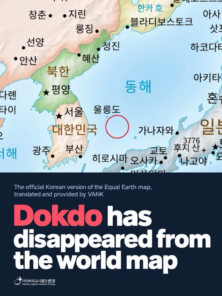
Dokdo has disappeared from the Korean-language version of the Equal Earth world map, prompting VANK to demand its reinstatement and raising questions over how the change was made. The map’s creator says the removal followed consultations with Korean and Japanese embassy representatives in Washington, D.C., but the Ministry of Foreign Affairs of the Republic of Korea denies that any such consultations or agreement took place.
The issue came to light in early October, when a teacher discovered that Dokdo was missing from the Korean-language map available on the official Equal Earth website, equal-earth.com. The map had previously shown Dokdo alongside Ulleungdo in the East Sea, with both islands labeled in Korean.
According to materials provided to the Kyunghyang Shinmun on Oct. 8, a version downloaded from the website on Sept. 6 included labels for the East Sea, Ulleungdo and Dokdo. By Oct. 7, however, Dokdo had disappeared from the map, while the East Sea and Ulleungdo remained.
Lee Hae-jung, a teacher at Sinchang Elementary School in South Jeolla Province and head of the Jeonnam-Gwangju Teachers for Educational Practice group, said he noticed the omission while preparing to show a world map to his students.
“I accessed the Equal Earth website to show the students a world map during class on Oct. 7 and noticed that Dokdo was no longer there,” Lee said. After comparing the map with a copy he had downloaded earlier, he confirmed that the island had been removed. He called for a clear explanation of why the change had been made.
Developed in 2018, the Equal Earth projection was designed to address the distortion of land areas associated with the widely used Mercator projection. It represents continents in proportions closer to their actual relative sizes. On Sept. 4, 2026, the United Nations General Assembly adopted a resolution recommending the use of equal-area map projections, including Equal Earth, and encouraging governments, educational institutions and international organizations to use them.
The Equal Earth website originally had no Korean-language edition. Its English, Chinese and Japanese versions also lacked an island at Dokdo’s location. The English version lists “East Sea” alongside “Sea of Japan,” but neither the island nor a Dokdo label appears on the map; Ulleungdo is shown without a name.
VANK created a Korean-language version of the map in November 2025, incorporating the East Sea, Ulleungdo and Dokdo, and provided it to Equal Earth. The version was officially added to the website in June 2026, with the island and its Korean name clearly marked. VANK said the omission was particularly troubling because the map had been available with the Dokdo label for several months. The organization’s own map-sharing website, equalearth.one, continues to display the version with Dokdo included.
After discovering the change, VANK sent a formal letter to the map’s creator demanding an explanation and the restoration of the island’s marking. In the letter, the organization said it was “deeply taken aback and regretful” that Dokdo had disappeared from a map it had created and supplied. It called on the creator to clarify whether the change resulted from a technical problem or an external request and to restore the marking promptly.
The dispute intensified after the creator’s explanation, relayed to VANK by email, was reported on Oct. 9. According to the Kyunghyang Shinmun, the creator said Dokdo had been removed after consultations with representatives of the South Korean and Japanese embassies in Washington, D.C. The creator described the decision as a “compromise solution,” explaining that the island had been removed from both countries’ language versions rather than being labeled differently on each map. The decision was also characterized as a “diplomatic decision,” with the creator asking for understanding despite the likely disappointment.
If accurate, that account would suggest that the removal was not simply a technical error or the result of a unilateral request, but a decision made after consultations involving representatives of both countries.
The Ministry of Foreign Affairs of the Republic of Korea, however, firmly denied that the government had discussed or agreed to removing Dokdo. In a statement on Oct. 9, the ministry said it was “entirely untrue” that Korea had agreed with Japan to delete the island’s marking from their respective language versions or had consented to its removal from the map.
The ministry said it had contacted the map’s creator through the relevant diplomatic mission after learning that Dokdo had disappeared from the Korean-language version. According to the ministry, the creator responded that the measure had been taken to ensure fairness between the two sides.
The ministry also disputed reports that the Japanese-language version had previously shown the island alongside the Japanese name “Takeshima” before removing it. “Based on what our ministry has been able to ascertain, Dokdo has never been marked on the Equal Earth map’s Japanese-language version,” it said.
The conflicting accounts have left the circumstances surrounding the removal unclear. VANK said it would continue seeking an explanation and pressing for Dokdo to be restored. The organization also plans to expand the international distribution of its own map through equalearth.one.
Another issue is the absence of an entry documenting the removal in Equal Earth’s official change log. Since the map was first published in October 2018, the website has recorded 47 changes, including the addition of language versions, revisions to place names, changes to territorial coloring and the removal of geographic labels. The Korean-language edition was listed as an addition on June 22, and the addition of a Swahili-language version was recorded on Oct. 8. However, no entry documents when or why Dokdo was removed.
VANK said it would seek clarification both on the removal itself and on why the change was not recorded in the change log.
Park Gi-tae, head of VANK, said Equal Earth’s central purpose was to correct geographic distortions in conventional world maps and help people understand the world more accurately and fairly. That principle, he said, should apply not only to the relative sizes of continents but also to the accuracy and consistency of the geographic information shown on maps.
The Foreign Ministry said it would continue conveying South Korea’s position to the map’s creator and seeking corrective action through the relevant diplomatic mission. It added that the government would remain alert to what it described as Japan’s efforts to frame Dokdo as a territorial dispute and continue explaining Korea’s position to the international community.
VANK, meanwhile, said it would continue promoting maps that accurately show the East Sea and Dokdo in Korea and abroad, arguing that the reliability of geographic information must remain central to any effort to make world maps more accurate.